The 1999 Best of the Net Awards
Annual Best of the Internet in Geography Awards
to the top ten geographical sites online
|
 |
Dateline: 12/31/99
By Matt Rosenberg
Geography, About.com
I selected these sites due to their outstanding quality among online sources for geographical information.
These sites really help to make the Internet a great source for geographical data and information online. Five
of the top ten this year are brand-new to this list; I've listed the rank for those sites that are returnees.
Without further ado, the top geographical sites for 1999...
10. Lonely Planet Destinations (new)
Lonely Planet has produced wonderful travel guides since the 1970s and now they provide basic information about every country in the "Destinations" section of their site. Each country page provides a bit of geographical historical, and travel information useful for travel as well as basic geographic research.
9. Xpeditions Atlas (new)
National Geographic provides over 600 of their crisp, black-and-white maps to print out or for online non-commercial use. Maps come in basic outline or detailed formats and are available as GIFs or as larger page-sized Adobe Acrobat Reader (PDF) files.
8. TerraServer (#5 in 1998)
Microsoft's TerraServer site is still fantastic but it hasn't increased its coverage much. They've utilized satellite images from around the world to create the world's largest database. This is still the best place to see a photo of your house from space.
7. Library of Congress Country Studies/Area Handbook Series (#9 in 1998)
The Library of Congress has expanded their site to provide 100 full-length online texts with the most detailed and informative resources for countries available online. Some of the information is a bit old so check the publication date.
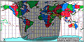
6. World Time Zone Map (new)
A great Java-based colorful time zone map that provides the current time around the world in each of the time zones. Scroll down to use the site's pull-down menu below the map for detailed time zone maps of the US, Europe, Russia, and more.
5. CIA World Factbook (#3 in 1998)
Updated annually, there's no better source for geographic, economic, political, or cultural data about a country than the CIA World Factbook. Each country or territory page also includes a very nice basic map and tiny flag image.
4. Microsoft Expedia Maps (#2 in 1998)
Expedia Maps has become more cumbersome and less user-friendly but it still provides great relief maps of obscure places around the world (their database is huge and will provide close matches if it can't locate an exact match, which is good for locating international places). Their street maps leave a bit to be desired.
3. InfoPlease.com (new)
The makers of the Time Almanac 2000 have placed the contents of their almanac online. This comprehensive online almanac includes great geographical goodies, world statistics, and country information, along with a plethora of additional data to please any trivia fanatic.
2. MapQuest (#1 in 1998)
MapQuest continues to provide excellent features on their site - especially their fantastic and up-to-date online road maps and driving directions. In the past year, MapQuest has increased their coverage of international cities, added driving directions between UK postal codes, and real-time traffic conditions for major U.S. cities.
1. TopoZone (new)
TopoZone, which launched on November 30 has been really making waves on the Internet. The site provides seamless USGS topographic maps of the entire United States online, for FREE! This site revolutionizes the entire arena of topographic maps as formerly, such maps were only available in paper and have recently become available on CD-ROM (and were not cheap). The jump to free online USGS topo maps was an awesome one, definitely deserving the #1 rank for 1999.
|