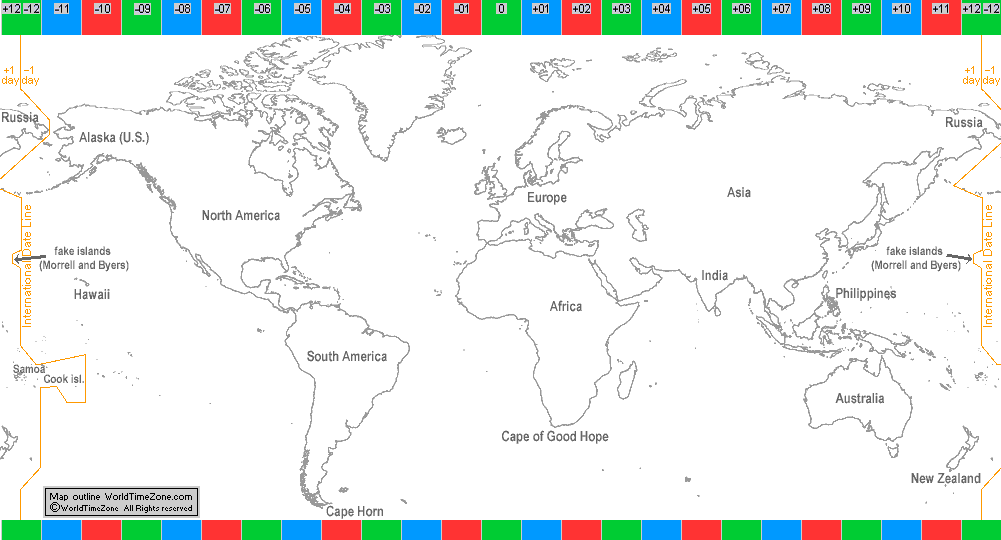
Philippines
The Philippines changed its date to the Eastern (Asiatic) side in 1845
as trade interests of the Philippines turned more and more away from the Latin America (around Cape Horn) and increased trade with China, the Malay peninsula, the Dutch East Indies (route around the Cape of Good Hope).
Kingdom of Samoa
Kingdom of Samoa was keeping Eastern (Asiatic) dates, which had been established by missionaries originating in Europe, Australia.
Cook Islands
The Cook Islands was keeping Eastern (Asiatic) dates, which had been established by missionaries originating in Europe, Australia, New Zealand.
(Chukotka, Russia)
(New Zealand)
(Chatham Isl.)
(Fiji)
(Tarawa, Kiribati)
(Majuro, Marshall Islands)
(Nauru)
(Tuvalu)
(Wallis and Futuna)
(Tonga)
|
I
n
t
e
r
n
a
t
i
o
n
a
l
D
a
t
e
L
i
n
e
|
Alaska (U.S.)
Alaska was a Russian territory (Russian America) until 1867 keeping the same date as at home (Eastern or Asiatic date).
On Friday, 6 October 1867 (Julian calendar, Asiatic date), Alaska prepared to have another Friday, 6 October 1867 (Julian calendar, American date),
but transitioning into Friday, 18 October (Gregorian calendar, American date).
The result was a total change of +12 days (+13 days adjustment from the Julian calendar to the Gregorian calendar and -1 day for moving from Asiatic date to the American date).
Morrell and Byers Isl. (fake islands)
Captain Morrell falsely reported the discovery of a small islands northwest of the Hawaii and named one island as Byers island (after New York owner of the ship James Byers) and
another island named after himself (Morrell island). In 1875 the British Admiralty removed the nonexistent Morrell and Byers Islands from its nautical charts, however these "fake islands"
continued to appear on different charts (maps, globes) until 1950-1970 by different publishers.
(Hawaii)
(Tahiti, French Polynesia)
(Marquesas Isl.)
(Tokelau)
(Phoenix Islands, Kiribati)
(Kiritimati, Kiribati)
|